Need Help?
Keep passengers and crew safe and fuel costs down
Turbulence is increasing and the current products to track and avoid it have significant limitations, due to imprecise location, subjectivity and time lag. To ensure passengers and cabin attendants are secured, commercial and business aviation pilots keep seatbelt signs on and will often change altitude looking for smooth air. This causes travelers to feel constrained and lose confidence in safety instructions, and can also lead to fuel inefficiencies. Your pilots and dispatchers need accurate information pinpointing the location and intensity of turbulence, to best advise passengers and crew and optimize fuel burn.
Turbulence is a major safety concern. Each year, a significant number of people are injured by turbulence, while not wearing seatbelts. Cabin attendants are particularly at risk. Occasionally, turbulence events require an aircraft to divert, with all the inconvenience and associated costs that entails. Lacking accurate information to guide them, pilots may opt to minimize risk, but this can adversely impact fuel costs. With industry-wide sharing of actual occurrences, in real time, pilots could take appropriate action with confidence.
> Latest news: IATA Turbulence Aware Grows Stronger in 2024
Need Help?
Access accurate, objective, aircraft-generated data
With objective, automated, in-situ turbulence reports, dispatchers, pilots and cabin attendants can:
- Know exactly where turbulence and smooth air are, and take appropriate action
- Be able to reassure passengers and cabin attendants
- Optimize fuel burn
Contribute to better situational awareness for all
By contributing objective, automated, in-situ turbulence reports, commercial and business aviation can:
- Help provide a more complete picture of atmospheric turbulence
- Improve the accuracy of turbulence data at different altitudes
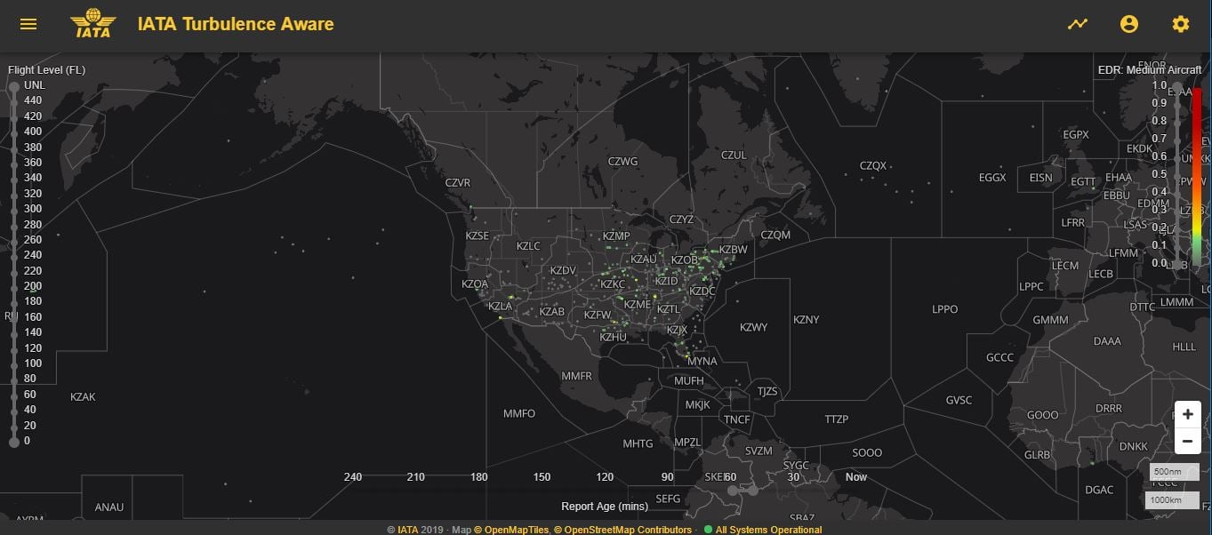
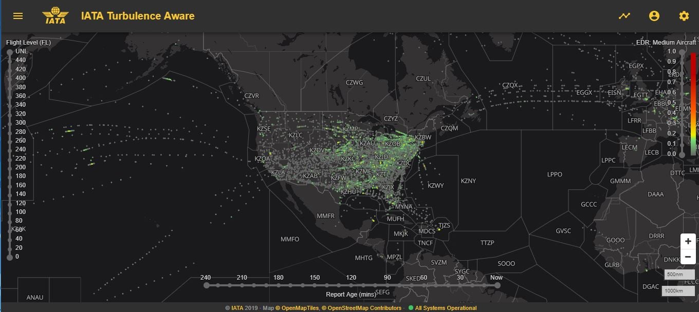
- Work towards increasing global coverage and eliminating blind spots
The images below show the difference in coverage of a few airlines reporting vs multiple airlines reporting. (Click on the images to enlarge)
 |
 |
Airlines Involved
Boost efficiency and your brand
- Protect passengers and crew from injury and aircraft from damage – Accurate information enables pilots and dispatchers to choose optimal flight paths
- Keep fuel costs down – Optimal flight altitudes use fuel efficiently
- Enable continuous improvement of flight operations – Archived data can be used to carry out strategic, data-driven evaluation of processes and procedures
- Preserve and improve your reputation – Smooth flights have a positive impact on the passenger experience and brand perception
Need Help?
Turbulence Aware serves aviation
A global, industry-wide, data exchange platform, Turbulence Aware receives the existing airline data from ground servers, performs quality control, deidentifies data, and provides the data back to airlines via a ground-to-ground system-to-system connection.
- Turbulence Aware viewer via Wi-Fi – Mapped real-time turbulence reports inform your operational decision-making
- Integration with in-house or third-party flight planning or in-flight weather tools – To speed up decision-making
- EDR-based – Energy/eddy-dissipation rate (EDR) is a calculated estimate of the atmosphere’s turbulent state. It is NOT a measure of the response of an individual aircraft. It is the official ICAO & WMO metric for measuring turbulence intensity
- Detailed report available for each data point – Including time, altitude, aircraft position, mean and peak EDR values as well as wind and temperature data, to increase situational awareness
- Anonymized data – To protect airlines’ identity and privacy
- Technical assistance – IATA provides assistance to airlines looking to implement open source EDR reporting software developed by the National Center of Atmospheric Research (NCAR)
Want better turbulence data?
Insightful content for you
What Our Customers Say
“IATA’s collaborative approach to creating Turbulence Aware with open source data means that airlines will have access to data to better mitigate turbulence. Using Turbulence Aware in conjunction with Delta’s proprietary Flight Weather Viewer app is expected to build on the significant reductions we’ve seen already to both turbulence-related crew injuries and carbon emissions year-over-year”
Jim Graham, Senior Vice President of Flight Operations at Delta Air Lines
"I'm a big fan of Turbulence Aware! For the first time, we have real-time objective turbulence information at our fingertips. In the past, all we had were forecasts maps with limited reliability and subjective PIREPS which are hit or miss in quality and quantity. Turbulence Aware adds to safety and passenger comfort by allowing me to make better altitude and routing decisions. At the very least, we're better equipped to advise our cabin crew and passengers on what to expect. I look forward to future integrations of the data to make it even more accessible within our daily workflow."
Tony Marotta, Director of Aviation, Pilot Business aviation flight department
“With safety and environmental sustainability as our top priority, we show our commitment towards responsible flying. We continue to innovate as one of the world’s leading airlines by adopting this new solution that combines technology and big data for more efficient flight planning not only to ensure a smooth journey, but also to reduce fuel burn, in turn lowering our carbon emissions. To make flying safer and more sustainable, the airline industry must leverage such digital innovations, and work together to share turbulence data for more precise forecasting.”
His Excellency Mr. Akbar Al Baker, Qatar Airway Group Chief Executive
“The big change was that we now know if we got an alert or a value, that’s fact, that’s measured, no discrepancy and that is a physical fact of what is going on at that moment in that area of the airspace”
Thomas Weber, Head of Flight Dispatch at Swiss International Airlines
"EDR is a powerful tool for making decisions on altitude changes and route changes, especially on long-distance international flights, due to its objectivity and ease of use. Up until now, flights over the Pacific have largely relied on predictions from meteorological data, and the pilots’ ability to obtain real time turbulence reports is limited.
However, it is now possible to obtain the latest EDR data using the aircraft's Wi-Fi to obtain a more accurate ENROUTE status via integrated weather tools running on EFBs. As a result, it not only realizes efficient altitude selection and comfortable flight with less shaking, but also reduces the risk of injury in the cabin.
We hope that more airlines will join in the future, and that EDR data will continue to grow."
Yuki Hayashi et al. Captain, Flight Operation Center at All Nippon Airways
In the news
Press Release: Qatar Airways joins IATA's Turbulence Aware platform
Avionics International Podcast: How IATA's 'Turbulence Aware' Helps Airlines Fly Steady
Airlines. magazine: A paradigm shift in managing turbulence
Knowledge Hub: Improve passenger experience with smoother and safer flights
In support of research and meteorological organizations to keep up with turbulence data demand, IATA is allowing access to live and historical wind, temperature and turbulence data (*EDR) from its Turbulence Aware Platform.
Available data:
- Live Global Turbulence Coverage
- Wind and temperature data
- Historical Data Archive in CSV format
- Average of 7,000+ flights per day and growing
- Average of 51,000+ turbulence reports per day
(*) Eddy Dissipation Rate
Parameters delivered for each report listed below:
| Parameter | Explanation | Example |
| Observation Time | Time of report in UTC | 2020-05-13T00:00:00Z |
| Altitude | Altitude Above Sea Level in feet | 35,000 ft |
| Latitude | Geographical coordinate of the report for latitude | 22 |
| Longitude | Geographical coordinate of the report for longitude | 120 |
| Peak EDR | Maximum EDR value in the calculation | 0.37 |
| Mean EDR | Average EDR value of the calculation | 0.12 |
| Wind Speed | Wind speed in knots | 40kt |
| Wind Direction | Wind direction in radial degrees | 270º |
| Static Air Temperature | Temperature in degrees celsius | -55.0ºC |
Data is available specific to your needs and budget. Contact us for more info.
Please fill out the form below and we will contact you shortly.
If you consider joining the program, data contribution is not required from the beginning.


